|
Getting your Trinity Audio player ready...
|
Because nothing says “Happy Anniversary” like hiking 17 miles with your teenagers
We had it all planned out for our 20-year anniversary trip: hike down the South Kaibab Trail, spend two glorious nights at Phantom Ranch (with real beds and lemonade on tap), then hike out via Bright Angel Trail with a night at Havasupai Garden Campground. A perfect down-and-up rim-river-rim adventure. So neat. So balanced. So… completely wrecked by construction at the bottom of the canyon to fix water pipes that had apparently broken 85 times already, but now was the time to fix them. Of course…
So our elegant loop turned into a hardcore out-and-back. Yep. South Kaibab down… and South Kaibab back up. No water on trail, except all in our packs, and a whole lot of heat, grit, and canyon silence.
Desert Roads, Rim Views, and One Last Night on Top
We left home around 9:30 a.m. on a Tuesday morning and began our desert road trip to Williams, Arizona, with a mandatory lunch stop at Pirate Cove Resort, our usual oasis by the Colorado River. It was all there: gorgeous views, a hot breeze off the water, good food, and heat so brutal it could roast your sandwich before it hit the table. The road in? Straight as a ruler but undulating like a camel’s spine, beautiful to look at, miserable to ride. Still, we made it to Williams in one slightly queasy piece and spent the night resting up for the adventure ahead.
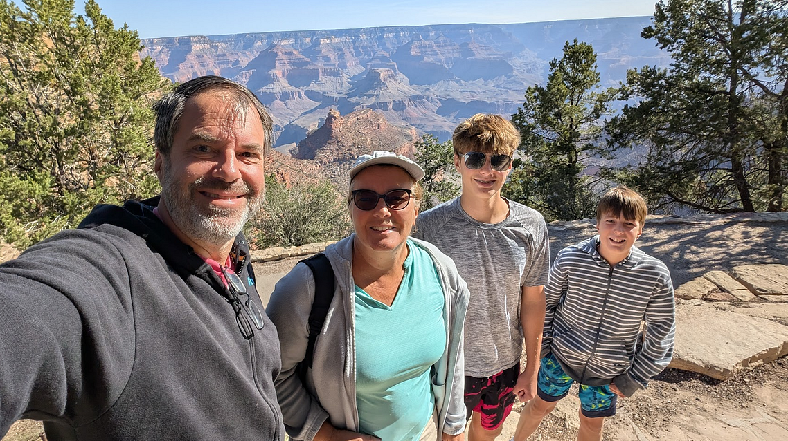
The next morning, everything aligned: breakfast at 6, on the road by 7, and at the Grand Canyon gate by 8, no line, no traffic, just that first breathtaking glimpse of the rim. We dropped our bags at Bright Angel Lodge, home base for the night and home to a dangerously charming gift shop where money disappears magically. No regrets, the plush blanket was necessary in the 104°F canyon heat. We then took the shuttle to Market Plaza for an early lunch and last-minute essentials (sunscreen, extra water bottles, and enough panic snacks to feed the Swiss army). With our gear sorted, we wandered the Rim Trail westward, soaking in the view, melting into the crowd of tourists, and pausing for ice cream before heading back to prep sandwiches and celebrate our 20-year anniversary with a very early steak dinner.
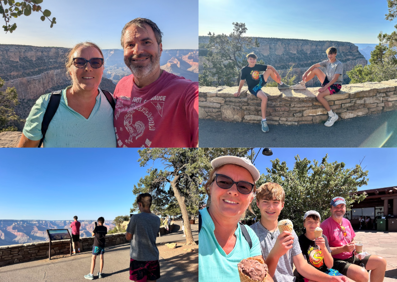
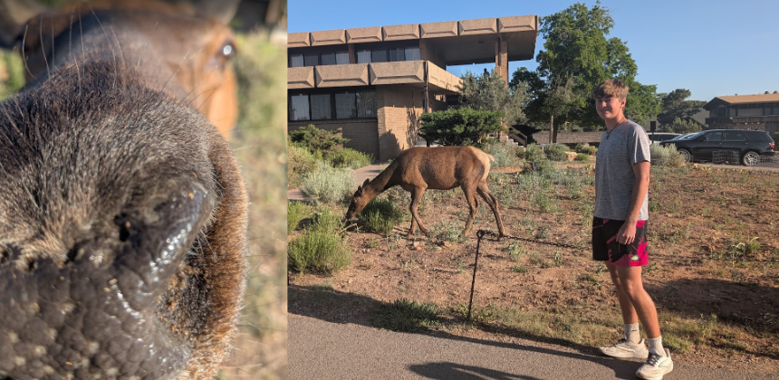
During golden-hour we took a walk east along the Rim Trail, where Tweeny’s phone nearly got eaten by a deer right out of his hand, while Teeny filmed the entire deer-slobber encounter like a wildlife documentary narrator and posted it on instagram. All that, of course, was much more eventful than our anniversary dinner, at least according to the boys!
After a few more photos, some with actual deer drool on the lens, we headed to bed early and set our alarms for 3 a.m.
Descent Day
We caught the 4:00 a.m. shuttle, because what better way to celebrate your 20th anniversary than by waking up in the middle of the night to voluntarily hike into a giant hole in the earth?
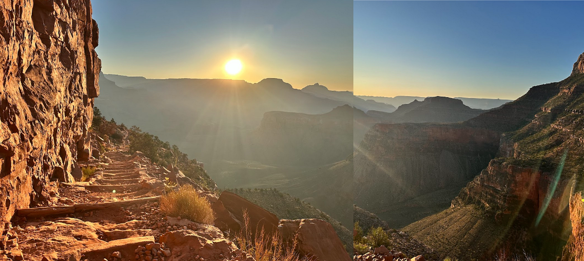
By 4:30, we were at the rim. By 4:40, we were hiking. The goal of the day: seven miles and 4,800 feet down into the canyon before 10 a.m., where temperatures were expected to reach 40°C/104°F. So… yeah… adventure and sweaty panic mode activated.
Headlamps on. Steep switchbacks ahead. And as we looked down the trail, we saw a string of tiny lights snaking through the canyon like some kind of misplaced Christmas light parade. It was a little surreal. A little terrifying. And a lot steep.
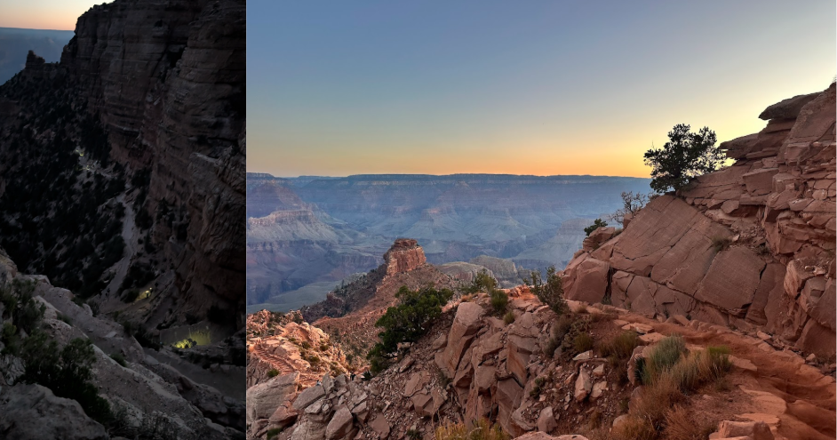
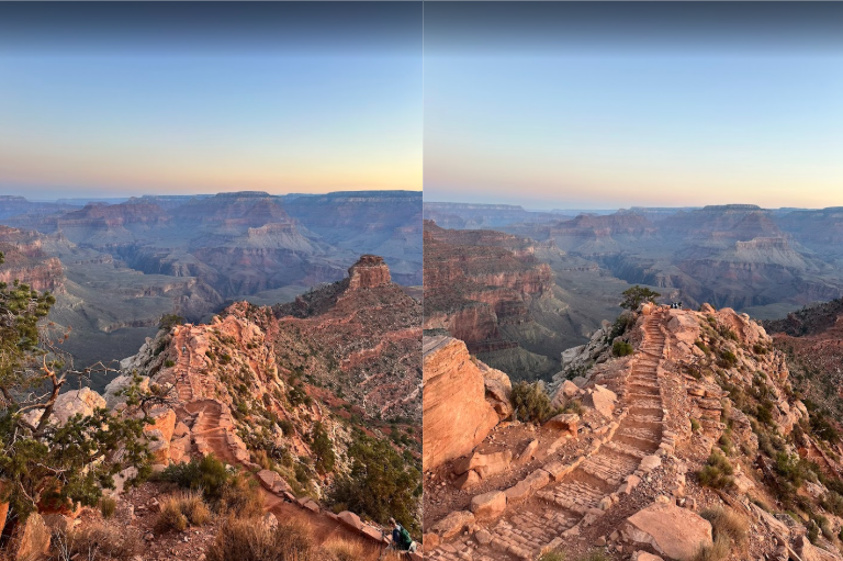
Within 10 minutes, dawn began to break. The holiday-lights vibe faded, and the South Kaibab Trail came into full view: stunning cliffs, dizzying drop-offs, and a whole lot of Wow, we’re really doing this.
Ooh Aah Point & Cedar Ridge
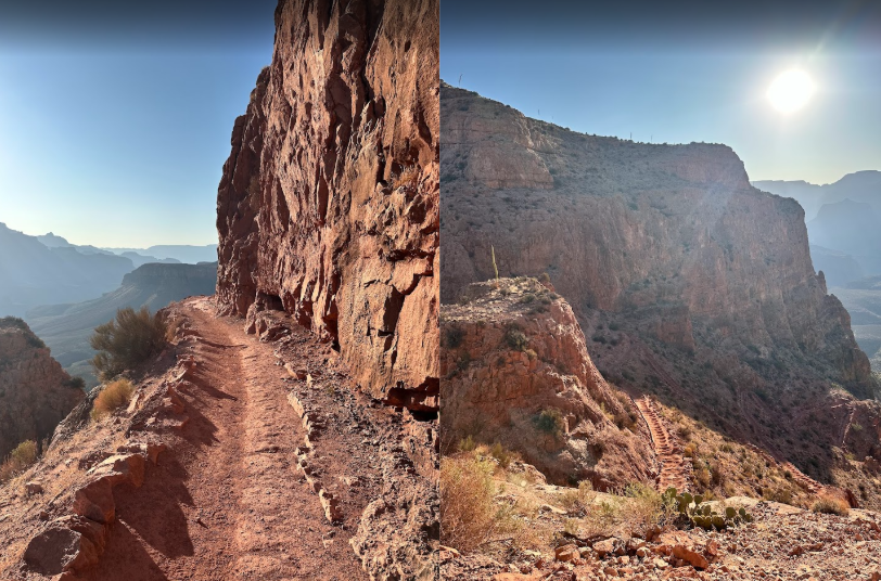
We reached Ooh Aah Point after less than a mile, and I may have accidentally renamed it OMG WOW. A few photos, a few more wows, and we moved onward toward the most iconic part of the trail, the path into the sky. Seriously, this is the most insane trail I’ve ever seen.
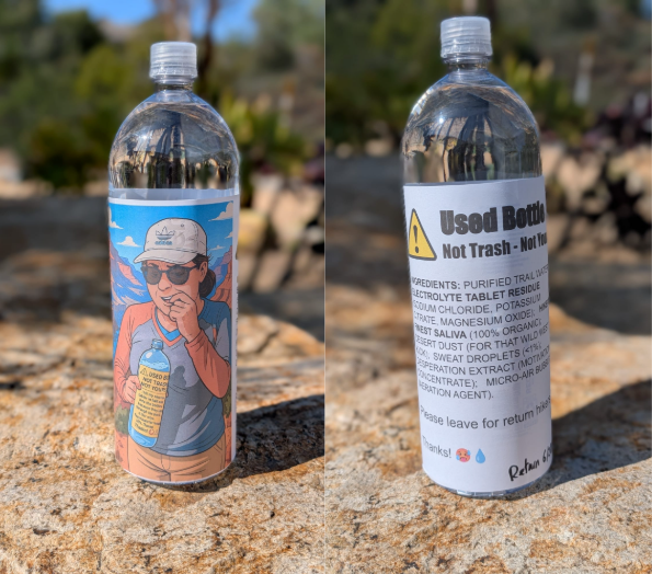
At Cedar Ridge, we cached our first gallon of water for the hike back up. Huge shoutout to Teeny for hauling an extra 4 kg the first 1.5 miles! Not that it slowed him down. He and Tweeny were usually miles ahead, checking in occasionally via walkie-talkie, two fast-moving dots several switchbacks below, who only paused to ask if we were still alive.
We dropped another gallon just before Skeleton Point, carried by my dear husband. This one came with the same lovingly labeled note, featuring a photo of me dramatically spitting electrolytes into a too-narrow bottle opening. Artistic? No. Effective deterrent for water thieves? We hoped so.
Around 6:30 a.m., we passed through the red and white switchbacks, just as we started crossing paths with hikers who had left Phantom Ranch as early as 2 a.m. It was steep, breezy, and impressive, both the landscape and the early-bird ambition. And a little surreal, knowing in two days, it would be our turn to hike back up.
The sun was up, but the air was still cool. Hope was still alive.
The Final Drop Before Lemonade
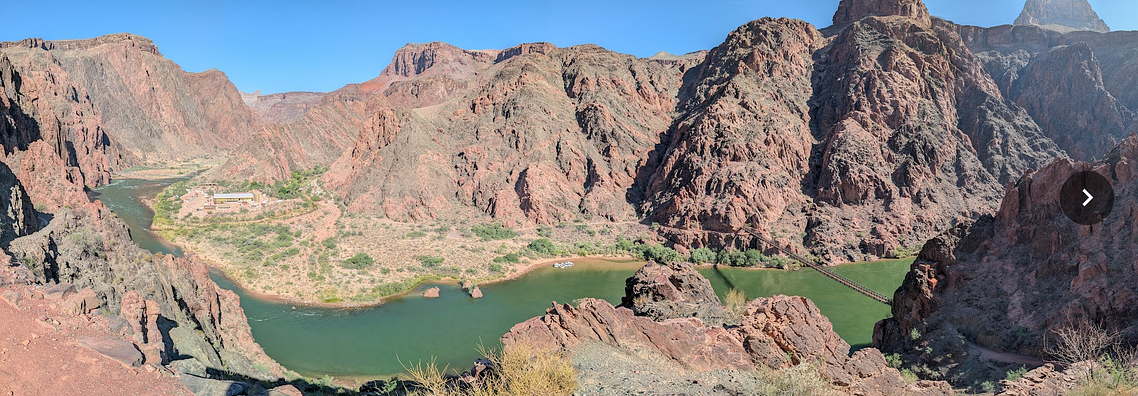
By 7:15, we reached the Tip Off, where the canyon finally revealed the Colorado River, the Black Bridge, and the very closed Silver Bridge. The descent suddenly felt real. So did my knees.
By 8:20, my husband and I were about a mile from the bridge and 1.5 from Phantom Ranch. The boys were far ahead, already taking pictures from the bridge, again appearing like tiny dots on the landscape. The temperature was rising, my legs were shaking, my knees were complaining, but my soul was pretty impressed with the surroundings.
Lemonade, Mule Mail, and the Kaibab Shuffle
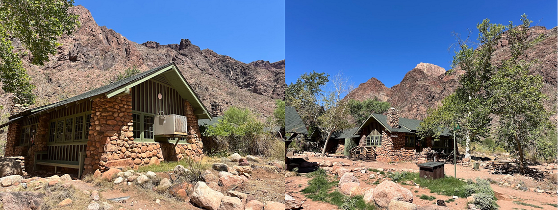
At 9:30 a.m., I stumbled through Bright Angel Campground and spotted the sacred destination: Phantom Ranch.
The boys were already at the canteen, sipping lemonade like canyon royalty. My husband had passed me earlier, mostly to make sure I didn’t accidentally wander off toward the North Rim in search of it. I didn’t.
We collapsed into chairs, rehydrated, and shuffled around the dusty campground in very achy slo-mo. (“It’s called the Kaibab Shuffle,” someone told us. Accurate.) Our calves were… very vocal at this point.
We sent postcards via mule mail to all the grandparents, because nothing says we survived the canyon like a dusty note carried out on four hooves. And just like that, a race began:
The postcards vs. the rest of us.
While the postcards would ride out on mules, then hop from mail truck to airplane to Swiss PostAuto and finally a bicycle courier…
Our route looked like this:
- Climb 4,800 feet out of the canyon
- Drive 8 hours home
- Navigate volleyball camps, vet visits, and a living room flood
- Squeeze in a dentist appointment, haircuts, and dog grooming
- Do all the laundry
- Pack again
- Drive to L.A. on July 4th (not our finest moment)
- Fly to Paris
- Take a train to Switzerland
- Visit my brother’s family
- Then drive to Grandparents #1…
…and pray they forgot to check their mailbox long enough for us to win.
Honestly? My money was on the mule.
But let’s get back to the bottom of the canyon
Röstigraben in the Grand Canyon
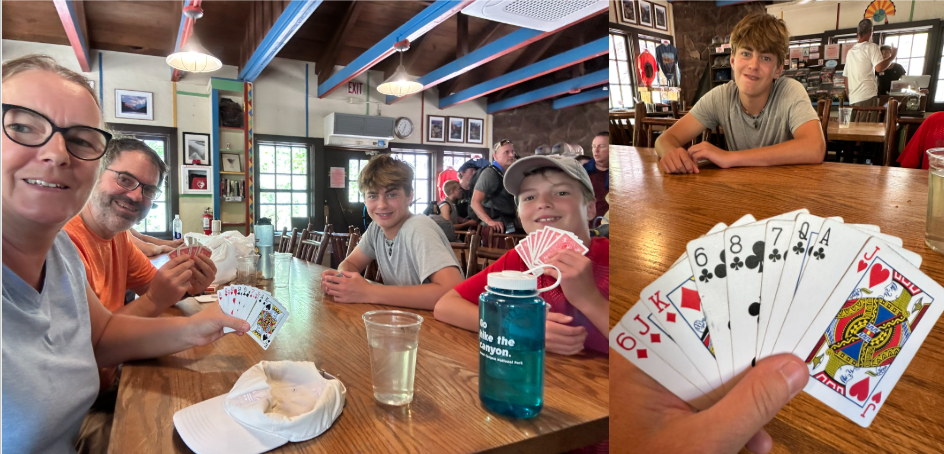
Our first afternoon at Phantom Ranch was all about electrolytes, naps, and card games. After a well-earned shower and a photo shoot of our new dusty, magical home, we returned to the canteen in the heat of the day to teach the boys Jass, more specifically, Schieber, the Swiss card game of champions.
Now, Schieber is usually played with a proper Swiss deck. You play in teams, and when your hand is weak, you can “schiebe”, pass the trump decision to your teammate. Simple, right?
Not quite.
Because somehow, the Röstigraben, that invisible but very real cultural divide between French- and German-speaking Switzerland, made its way right into our game.
My French-Swiss husband had only brought poker cards. I (growing up in the German part of Switzerland) immediately suspected he was making up half the rules. But then again… I may have “accidentally” slipped in a few from Belote, the French card game I used to play with my parents, and forgotten how to play a game I hadn’t played in 35 years. Anyways… The boys were confused but game. We played anyway. And somehow, it was still competitive.
And for the record? My team always won.
Just look at that hand. I passed the trump to Teeny, and what did he say?
“Clubs.”
Yes, Teeny. YESSSS. Jassss!!!
Creek Wisdom and Canyon Steak
While we were playing cards, a ranger stopped by and offered a spontaneous hydrology talk by the creek. We learned that Bright Angel Creek’s water, the one flowing peacefully past Phantom Ranch, comes from snowmelt on the North Rim and gets pumped uphill through pipes that run beneath the Silver Bridge. Which, of course, explained why the River Trail and that very bridge were closed: broken pipes, heavy machinery, and a long-overdue repair project perfectly timed with our visit.
That evening, we showed up for the 5:00 p.m. steak dinner, unforgettable, fully deserved, and 100% necessary. Juicy steaks, crisp salad, baked potatoes, carrots, cornbread, and even dessert. After a day of bagels, trail snacks, electrolyte tablets, and canyon dust, we devoured every bite. I may have had three bowls of salad, one of them for dessert.
Recovery, River Magic, and One More Steak
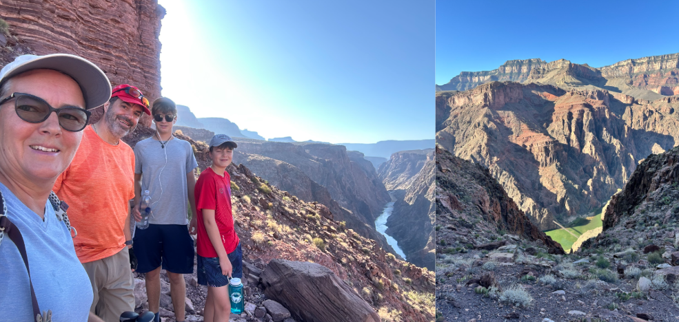
We were up again before sunrise, not to hike out, but to make the 5:00 a.m. breakfast. Eggs, bacon, sausage, pancakes, and canned peaches had never tasted so good. Most people were fueling up to climb back to the rim. Not us. We were doing what every responsible, adventurous family does on Day 2 of a canyon adventure: a bonus hike.
We climbed a few miles up past the Phantom Ranch Overlook to find a peaceful perch above the river. My calves handled the uphill just fine… but on the way down? Nope. Loud rebellion. Apparently, they hadn’t signed up for a two-day canyon tour.
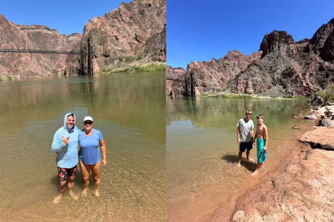
By midafternoon, the desert air hit 43°C (110°F), so we headed to Boat Beach for a cold plunge in the Colorado River. The water was probably 14°C (57°F), a solid “YELP” temperature, but it was heaven for our canyon-crushed feet.
We soaked in the icy flow while roasting in desert heat. It was contrast therapy at its finest.
And then came the hikers, two of them, soaking wet and dressed in dark long sleeves and jeans, started their ascent… at 2:30 p.m. Bold move, considering every sign in the canyon warns against hiking between 10 a.m. and 4 p.m. They had fully drenched themselves before heading up.
We wished them luck. And maybe divine hydration.
On our way back, Tweeny flopped into Bright Angel Creek, like a happy, overheated otter, awkwardly lying down in the knee-deep current like it was a spa day. Well, it kind of was.
We showered, packed up, and savored one last nap in the blissfully dark cabin. And went for another steak dinner.
That salad was calling me like it knew what I’d been through. The steak was fantastic, again. Cornbread and dessert? Still divine.
By 7:00 p.m., we were in bed. Alarms set for 3:00 a.m., because yes, we were doing that trail again. Uphill, in the dark, in full misadventure mode.
The Ascent
Sweat, Switchbacks, and Survival Snacks
We hit the trail at 3:30 a.m. Headlamps on. Bats flapping in our faces. The desert sky was still in full star mode.
First stop: the bathroom just past the campground. Because every ounce not carried is an ounce of joy.
We crossed the Black Bridge and the tunnel, and then the climbing began. The first 2 miles were brutal. Hot, dusty, vertical. I could track my husband by the sweat droplets he left in the dirt. Romantic, right? No seriously, it was pitch black but somehow the hottest, sweatiest part of the trail.
By Tip Off, 4.4 miles from the rim, the sun was up, the air had cooled, and we took a break for breakfast: bagels, beef jerky, cereal bars. I was so over trail food I nearly cried when I found an apple in my pack.
The red and white switchbacks came next, famously the hardest part.
Honestly? They weren’t so bad.
Teeny was long gone. Tweeny was bouncing up the trail like a caffeinated mountain goat, babbling into the walkie-talkie about “efficient middle schoolers” while I tried to show up as resilient, middle-aged mom at the back of the pack.
But I was still cracking jokes into the walkie-talkie, so… we’ll call that a win.
At Skeleton Point, I finally caught up to Teeny. As I sat down he asked,
“Can we go now?”
No, Teeny. NO!
Mama needs a break.
Sit. Stay. Like a good boy.
He gave me one minute, then the two mountain goats were off again toward Cedar Ridge.
We knew our first water cache was coming up. My husband had its precise completely wrong GPS coordinates saved on his watch. Didn’t matter. Super-efficient GeoCache Tweeny found the stash before we even arrived.
Thank you, Tweeny, not just for saving nature, but also for rescuing it from my ridiculous water bottle labeled with a picture of me spitting electrolytes, designed to keep other hikers away.
Still no sign of Teeny. He was probably further up the trail, nose in his phone, waiting for his slow-motion parents. We finally spotted him from below, hiking like he was escaping from… something.
We regrouped at Cedar Ridge, where we found our second cached gallon. Even the wildlife had obeyed the warning label. Success.
From Skeleton Point to Cedar Ridge was the most stunning part of the climb. From Cedar Ridge to Ooh Aah Point, those stone stairs carving straight into the sky amazed me again.
We climbed slowly and steadily, inching toward the final switchback…
And there they were: the two guys in long sleeves and jeans from the day before.
Turns out they had only made it to Tip Off before a ranger told them they could sleep there. They looked absolutely toasted. Still smiling, but done.
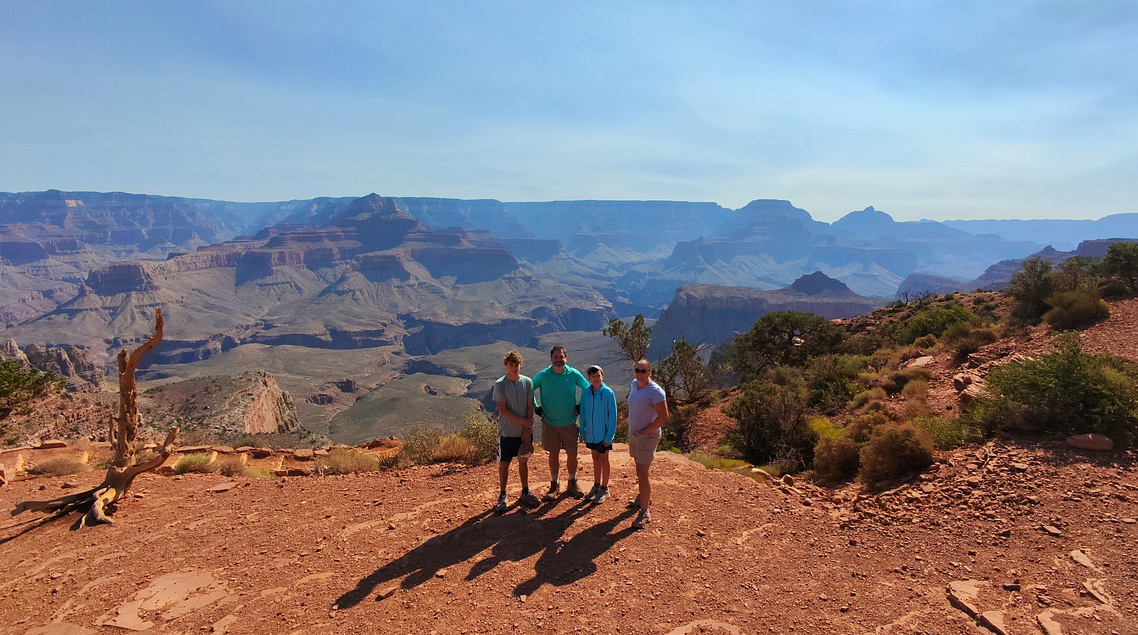
We climbed out, victoriously, by 10:00 a.m. We did it!
• Descent: 4h45
• Ascent: 6h30
• Average Pace: ~1 mile every 35 min down / 45 min up
Final Thoughts
The Grand Canyon gave us everything: Heat, beauty, sore calves, trail snacks we never want to see again, a canyon-wide RöstiGraben, cold rivers, and lemonades worth hiking for.
We may not have done the loop we planned, but we came back full of stories, and with just a little more canyon in our legs and hearts than we expected.
And we got so very lucky.
Because just one week later, a fire broke out at the North Rim, and all that beauty disappeared into smoke and destruction.